

An air quality map shows conditions across the United States on Wednesday as Canadian wildfire smoke is forecast to continue to spread across the country, prompting air quality alerts and advisories in multiple states.
The map shows parts of Minnesota, Iowa and Wisconsin are facing unhealthy air, according to a federal measurement system called the Air Quality Index.
The index has six ratings:
- Good
- Moderate
- Unhealthy for sensitive groups
- Unhealthy
- Very unhealthy
- Hazardous
Sensitive groups include those who have a heart or lung disease, as well as older adults, children and pregnant women.
Air quality advisories were issued for Wisconsin, Michigan and Ohio, while alerts have been issued in New York State, Maine, New Hampshire, Connecticut, New Jersey, Pennsylvania, Nebraska, Minnesota and Iowa, according to the National Weather Service.
New York City and some of the surrounding areas were under an air quality alert that will be in effect from 11 a.m. to 11 p.m. ET on Wednesday, CBS News New York reported.
Wildfire smoke could be visible in other areas but may not impact air quality. In Maryland, for example, smoke had been expected to keep skies hazy overnight but remain at high altitudes, having little impact on the quality of air at the surface, CBS Baltimore reported.
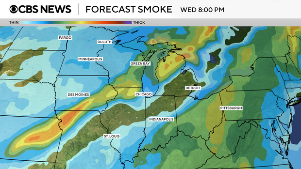
These Canadian wildfire smoke maps show where the smoke is forecast to move on Wednesday.
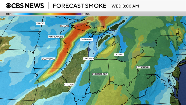
More than 200 fires are burning in Canada, with over 100 of them considered out of control, according to the Canadian Interagency Forest Fire Centre. Tens of thousands of residents across three provinces have been evacuated due to the blazes.
Source link

